Comment anticiper et mesurer les ressources en eau de la planète afin de s’adapter aux effets des changements globaux ? C’est l’un des objectifs du futur satellite SWOT, développé dans le cadre d’une collaboration franco-américaine lancée il y a près de 10 ans, qui va révolutionner les pratiques à 891 km d’altitude avec un altimètre capable de surveiller les fleuves et lacs de notre planète. Décollage prévu en avril 2021.
Le 11 novembre 2016, à Marrakech, sept acteurs de l’eau français, organismes de recherche, financeurs et gestionnaires (AFD, CNES, OIEau, Compagnie Nationale du Rhône, IRD, Irstea, BRLi) ont officiellement signé un accord de groupe de travail afin d’utiliser le futur satellite SWOT pour suivre les ressources en eau de la planète.
Anticipant sa mise en service prévue en 2021, des scientifiques dans les laboratoires d’Irstea s’activent pour mettre au point des algorithmes qui permettront de convertir les données du satellite en données opérationnelles pour le suivi de la ressource en eau à l’échelle de la planète. Avec des résultats plus que satisfaisants…
Un rapport de la NASA, le projet GRACE (Gravity Recovery and Climate Experiment), effectué entre 2003 et 2013 affirme que l’eau douce se fait rare et que nous en manquons de plus en plus. En effet, sur 37 cours d’eau étudiés, 21 sont en voie d’épuisement. Huit d’entre eux n’ont d’ailleurs peu ou pas de ressources d’eau à l’heure actuelle. Ils pourraient donc potentiellement être à sec à l’avenir, ce qui serait un désastre pour toutes les formes de vies qu’ils supportent et pour nous, humains. Il est donc essentiel de les surveiller … de près.
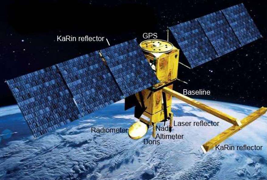
Les satellites ont révolutionné l’océanographie, ils bouleverseront demain l’hydrologie. La mission franco-américaine Swot (Surface Water and Ocean Topography) devrait en être la pierre angulaire en emportant dans l’espace un instrument de rupture technologique, un radar interférométrique large fauchée dénommé KaRIn.
En 2021, le satellite SWOT, construit par Thales Alenia Space, survolera la terre équipé de cette technologie de rupture [1], qui effectuera des mesures de hauteur des eaux de surface sur deux fauchées de 60 km de part et d’autre de la verticale du satellite (contre quelques kilomètres actuellement !). Le tout avec une précision altimétrique (technique d’observation à hauteur des mers) de l’ordre de 10 cm, lorsque les mesures haute résolution sont moyennées sur des zones de 1 km². Parmi les atouts de l’approche satellitaire : la possibilité de couvrir les fleuves des zones peu accessibles de la planète et les moins bien renseignées, la transparence de l’information entre pays en particulier sur les bassins transfrontaliers, une couverture globale du globe, ainsi qu’une homogénéité de la mesure, de ses traitements et de son archivage. Ainsi, par exemple, seules deux stations hydrométriques étaient encore récemment opérationnelles sur le fleuve Congo pourtant long de 4700 kilomètres et traversant quatre pays. Le projet SWOT d’un milliard de dollars est financé au deux tiers par la NASA et un tiers par le CNES.
Du high-tech pour la mesure des débits des cours d’eau
Plusieurs équipes scientifiques françaises et américaines travaillent depuis environ sept ans sur la conversion des données du type de celles qui seront acquises par le satellite en débits des rivières et des fleuves. Les données brutes reçues depuis l’espace sont traduites en hauteurs d’eau par rapport au géoïde [2]. Les spécialistes en hydraulique et en assimilation de données du centre Irstea Montpellier ont intégré le projet il y a trois ans et ont appliqué une nouvelle méthode de calcul des débits qui s’est avérée particulièrement performante. « Notre méthode s’appuie à la fois sur un modèle hydrodynamique complet 1D, le logiciel SIC développé depuis plus de 25 ans par Irstea et adapté à de nombreux contextes, et la méthode 4D-VAR développée par l’université de Grenoble et utilisée par Météo France ainsi que par le Centre Européen pour les Prévisions Météorologiques à Moyen terme [3] pour les prévisions météo en particulier en France et en Europe. », explique Pierre-Olivier Malaterre responsable de l’équipe montpelliéraine Gestion Hydraulique, Optimisation et Supervision des transferts d’Eau. « Notre technique plus sophistiquée que celles utilisées par nos confrères a donné les meilleurs résultats en termes d’estimation des débits ».
Pour appuyer cette affirmation, les scientifiques se réfèrent à un travail comparatif des différentes méthodes, réalisé pour l’instant sur deux des 19 « fleuves tests » choisis dans le cadre du projet SWOT. « Sur la Garonne, nous avons travaillé sur des données générées par nos modèles et reproduisant un scénario hydrologique réel ayant eu lieu en 2010, avec une large gamme de valeurs de débits (de 50 à près de 2000 m3/s) ». D’autres tests sont en cours, dans le cadre d’une thèse pilotée par Irstea et cofinancée par Irstea et CLS [4] en collaboration avec l’université de l’Ohio. Ils concernent des scénarios de débits sur les fleuves du Pô en Italie et du Sacramento en Californie à partir de données simulées de manière très réaliste a priori identiques à celles qui seront fournies par le satellite SWOT.
Ainsi le simulateur de données intègre différentes perturbations (roulis du satellite, dilatation thermique des mats du satellite portant les instruments radar, effets de la troposphère humide, réflexions des ondes radar sur les reliefs, etc.) qui dans l’espace perturberont le signal. « Là encore, les premiers essais comparatifs donnent l’avantage à la méthode de calcul d’Irstea. De quoi renforcer notre forte expertise (déjà reconnue à l’international !) dans le domaine de la modélisation hydraulique et de l’assimilation de données. »
Une nouvelle technologie en appoint du réseau hydrométrique actuel
Cependant, malgré les bons résultats affichés pour la mesure des débits hydrologiques à partir des données SWOT, la technologie satellite ne vise pas à remplacer les réseaux de mesure hydrologique de terrain. En effet, la résolution actuelle du satellite ne permettra de surveiller que les grands fleuves de plus de 100 mètres de large (ou 50 m si cela est possible). En France, seuls nos cinq principaux fleuves pourront ainsi en bénéficier.
D’autre part, compte-tenu de la trajectoire du satellite autour de la terre et de sa vitesse, la fréquence des mesures en un lieu donné ne sera que de deux à cinq mesures par cycle de 21 jours. « D’où l’intérêt de pérenniser et/ou développer le réseau actuel de mesures sur le terrain. En France, cela représente plus de 3000 stations qui relèvent automatiquement le niveau des cours d’eau à de grandes fréquences (quelques minutes à quelques heures). Ces données sont combinées avec des relations hauteur-débit étalonnées régulièrement par les équipes terrain qui effectuent des mesures ponctuelles de débit, appelées jaugeages », explique Michel Lang, hydrologue au centre Irstea de Lyon. « Certains bassins expérimentaux, comme ceux gérés depuis plus de 50 ans par Irstea (Réal Collobrier et Orgeval), sont équipés de multiples capteurs qui permettent de suivre finement les différentes composantes du cycle de l’eau et d’améliorer nos outils de modélisation hydrologique ».
Les données acquises sur les sites hydrométriques et celles fournies par les satellites sont complémentaires. Les premières ont une résolution temporelle très fine qui permet de suivre les phénomènes hydrologiques rapides comme par exemple les crues éclair dans les rivières, et sont disponibles sur plusieurs décennies ce qui permet de suivre les effets du changement global sur les ressources en eau. Les secondes peuvent, sur les grands cours d’eau, donner rapidement des estimations de débit en de multiples points, dont certains difficiles d’accès au sol.
L’hydrologie spatiale se fédère en France
Devant la masse de données que fournira le satellite à partir de 2021 (sept térabits [5] par jour !), il s’agit en amont de se préparer à les recevoir, les traiter et les analyser. Ainsi le CNES s’apprête à renforcer sa capacité d’analyse des données aidé en cela par les apports du programme d’investissement d’avenir (PIA).
Ces données en accès libre permettront l’émergence de nouveaux outils pour répondre à de grandes problématiques environnementales dans le domaine de l’eau : protection, alerte et suivi des crues, gestion des ressources, navigation, production hydroélectrique, agriculture, etc.
(Source : IRSTEA – 8/12/2016)

[1] Un radar interférométrique à large fauchée. La fauchée désigne la bande analysée par 2 antennes radar situées aux extrémités de 2 bras de 10 mètres chacun.
[2] Le géoïde est l’ellipse hydrologique de référence établie à partir du niveau moyen des océans en supprimant l’action du vent, des courants et des marées.
[3] ECMWF Reading, UK
[4] Collecte Localisation Satellites
[5] Un térabit représente 1012 (= 1 000 000 000 000) bits